Download Air Navigation Pro Apk app for Android
Air Navigation Pro Apk is a high-quality flight assistant app, with real time GPS navigation for mainly VFR pilots. You can plan and track your flights and have access to a database of worldwide airspaces and waypoints. Prepare your flight better than ever with Air Navigation Pro!
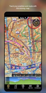
MOVING MAP AND FLIGHT PLANNING FUNCTIONS
The Moving Map displays aeronautical charts as background, interactive waypoints, airspaces and planned route. Plan and edit with the Flight Planning function, directly from the moving map or by searching the waypoint’s database. The planned route will be displayed on the moving together with further information such as next point distance, track, heading and many more.
APPROACH CHARTS
The georeferenced approach charts are designed for maximum visibility. Displaying now also in the 3D view, they provide increase awareness of your surroundings during take-off and landing.
AERONAUTICAL CHARTS, PROFILE VIEW AND 3D VIEW
We provide a worldwide selection of free and paid charts including the main ICAO charts. The Profile View gives all terrain information for better situation awareness and safety enhancement. The 3D view provides enhanced terrain awareness and is compatible with georeferenced approach charts.
List of charts available on http://services.airnavigation.aero
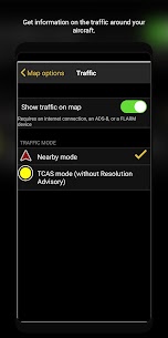
INSTRUMENTS, ALERTS, AND TRAFFIC AWARENESS
Simulate aircraft instruments, for both helicopters and airplanes, by gathering information from GPS and other sensors. Set a wide range of alerts customized to your needs, for example to notify you when a target altitude has been reached or abandoned.
Enhance safety with the Traffic Awareness feature by decreasing the risk of a collision, fly simultaneously or follow another aircraft that you marked*
*requires GSM internet connection or an external device
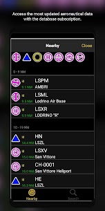
DATABASE AND SEARCH ENGINE
Global aeronautical database with over 200,000 waypoints and 50,000 airspaces constantly being updated. Search and navigate to specific locations. Also create, edit and export custom waypoints and routes and create aircraft profiles for both helicopters and airplanes.
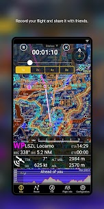
LIVE TRACKING, FLIGHT RECORDING
Follow your flight in real time, record your flight, replay and analyse your trace. The recorded flight can also be exported as KML file and be viewed on Google Earth.
ADDITIONAL FEATURES
– Night Vision
– Sharing Functions and Live Tracking
– Supports external modules
Check out more features at https://airnavigation.aero/
REQUIREMENTS
Some “WiFi only” tablets do not include an internal GPS receptor. An external sensor is needed for these devices. Check out our Online User Manual at http://manual.airnavigation.aero
This app offers yearly auto-renewable subscriptions.
Please read Air Navigation Pro terms of use: https://airnavigation.aero/terms-of-use.html
*Please note that this software isn’t intended to replace a certified navigation device. You should always use official aeronautical documentation when preparing and performing a flight and always use certified navigation devices when performing a flight.
Air Navigation Pro for Android V3.4 is supported from Android version 6.0 (Marshmallow API level 23) to higher versions.